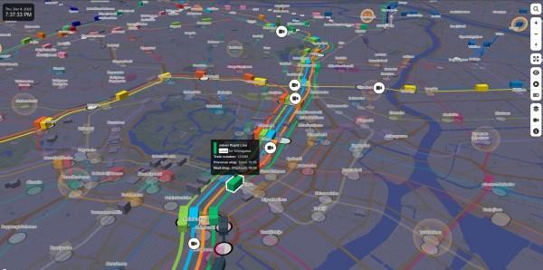
Trains in operation and airplanes that are arriving or departing are represented on a realistic 3D map with smooth animation. This is a “digital twin” that looks exactly like the real world in the digital world.
Users can freely move around on the 3D map and zoom in on the places they want to see to know the “now” of Tokyo. It can be used in various ways such as looking for the transfer route as a route map, checking the destination town and weather before going out, just watching the way along the railway by automatically tracking a train and judging if you should dash to not miss the final train from the current position of the train.
Mini Tokyo 3D is a web application that you can run in any web browser, regardless of device, such as PCs, smartphones, tablets, and set-top boxes.
You’d think by 2022 we’d all be seeing this type of data. It is fully possible (and the code is open sourced on Github). Personally, I’d like to see our council rubbish trucks being displayed like this, so we can see when they are arriving.
#technology #opensource #tracking #publictransit #Tokyo